

Science Lesson: Earth’s Climate
Once students understand how water moves around the planet and the role of the oceans in the water cycle, they focus, in this lesson, on regional climates, figuring out the factors that influence a location’s climate.
Science Big Ideas
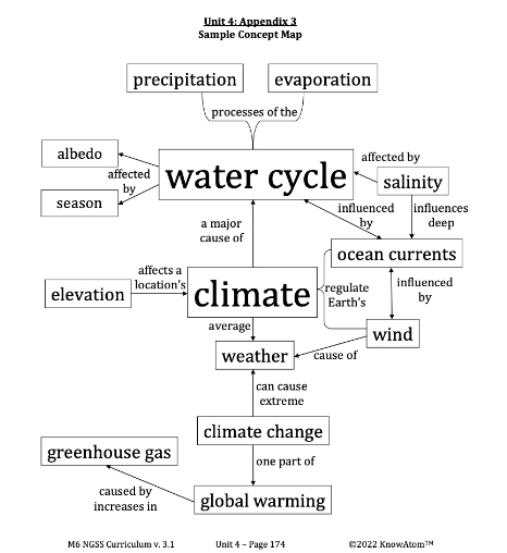
- The water cycle, powered by energy from the sun, is a major influence on weather and climate around the planet.
- The sun heats the ocean near the equator, and that thermal energy is then carried toward the poles as water and air molecules interact and exchange heat.
- Wind pushes against the ocean, creating ocean surface currents (which are different from deep ocean currents, which are a result of the different densities of salt water around the world).
- Weather and climate are complex. They are influenced by many factors, including Earth’s uneven heating as well as a region’s location, latitude, altitude, and geography.
- The ocean interacts with land and air to influence climate. Locations near the ocean have some similar weather patterns.

Discover Complete Hands-on Screens-off Core Science Curriculum for K-8 Classrooms
Prepared hands-on materials, full year grade-specific curriculum, and personalized live professional development designed to support mastery of current state science standards.
Science Essential Questions
- How is the water cycle responsible for distributing heat around the planet?
- Why does heat transfer from the water vapor molecules to the atmosphere?
- What causes wind?
- How is the movement of air related to the ocean?
- Why does Earth’s tilt affect the movement of wind currents?
- How do the global winds influence the movement of ocean surface winds?
- How does a location’s latitude affect its climate?
- How can locations at the same latitude around the world have different climates?
- Why do marine climates have more moderate temperature changes in the summer?
- Why do temperatures decrease at higher elevations?
Common Science Misconceptions
![]() Misconception: Individual weather events can be used as evidence for or against climate change.
Misconception: Individual weather events can be used as evidence for or against climate change.
![]() Fact: Weather events last a short amount of time, but climate is the average weather for a region. No individual weather event can “prove” that climate change is or is not happening.
Fact: Weather events last a short amount of time, but climate is the average weather for a region. No individual weather event can “prove” that climate change is or is not happening.
![]() Misconception: Earth gets closer to the sun in the summer and farther away from the sun in the winter.
Misconception: Earth gets closer to the sun in the summer and farther away from the sun in the winter.
![]() Fact: The angle at which the sun’s rays reach Earth, caused by Earth’s tilt, is the cause of the seasons.
Fact: The angle at which the sun’s rays reach Earth, caused by Earth’s tilt, is the cause of the seasons.
Science Vocabulary
Elevation : the height of a location above sea level
Wind : moving air
Lexile(R) Certified Non-Fiction Science Reading (Excerpt)
Analyzing Earth from Space
One day in July 2005, far above Earth’s surface, a satellite named Aqua was collecting data on the complex interactions that drive the water cycle, focusing on interactions between the energy produced by the sun and water on Earth.
From its perch in space, Aqua gathers information about evaporation from the oceans, water vapor in the atmosphere, clouds, precipitation, soil moisture, sea ice, land ice, and snow cover on the land and ice.
One area where it was gathering data was Cape Verde, a group of 10 islands near the equator. In July 2005, temperatures were very high. Aqua recorded the moment when the ocean’s surface reached a critical temperature—27 degrees Celsius (80 degrees Fahrenheit). At this temperature, ocean water begins to evaporate. Aqua collected data showing that millions of tons of water vapor evaporated from the ocean every hour.
Scientists could then track the movement of that water—and the resulting weather it caused—around the planet. The data from the satellites provide evidence that water is constantly in motion, in water vapor and in ocean currents. The warm ocean water and water vapor produced at the equator continually carry the sun’s energy toward the poles. This is significant because the transfer of heat around the planet regulates Earth’s climate. Without it, regions near the equator would be much hotter, while regions near the poles would be much colder.
Global Patterns, Local Climate
As ocean and air currents carry heat, they influence the climate of the land. The Gulf Stream offers a good example of how the water, air, and land interact to influence climate. The Gulf Stream is an ocean current that flows eastward from the Gulf of Mexico, around the southern tip of Florida, and along the East Coast up to Iceland and Norway. It is like a warm river that moves over and through the colder waters of the Atlantic Ocean.
As it travels north, the warm water in the Gulf Stream cools off because of evaporation caused by wind moving over the water. That evaporation results in water that is saltier and denser. By the time the water reaches the North Atlantic Ocean, the water is so dense that it begins to sink down through less salty and less dense water. Here, it joins another current that moves south, toward warmer, less-dense water, continuing the cycling of water around the planet.
Florida’s climate is influenced by the Gulf Stream, as well as the state’s location relative to the equator. Remember that different parts of Earth receive different amounts of sunlight because of Earth’s tilt. Regions that are closest to the equator receive the most direct sunlight and so have the warmest temperatures. Regions that are closest to the poles receive the least amount of direct sunlight and so have the coolest temperatures.
Scientists measure a location’s position relative to the equator as its latitude. The equator’s latitude is 0 degrees, while the poles’ latitude is 90 degrees. South Florida has a latitude of around 26 degrees north of the equator (26N).
In addition to its latitude, South Florida’s climate is also affected by its location next to the warm ocean water. The ocean has the effect of keeping temperatures warmer in the winter and cooler in the summer than other southeastern states. This results in what scientists call a marine climate.
This is because of how heat always moves from warmer regions to cooler regions seeking equilibrium. The ocean has a higher heat capacity than land. Heat capacity is the energy required to raise the temperature. In other words, it takes longer for water to heat and cool than the land.
Let’s think about South Florida again. South Florida (and all of the United States) is in the Northern Hemisphere. Summer occurs when the North Pole is tilted toward the sun. This causes temperatures to increase. As the sun heats Earth, the land becomes warmer before the ocean does because the ocean has a higher heat capacity. As a result, heat transfers from the warmer land and the air above the land to the cooler ocean. This transfer of energy (heat) from the land to the ocean causes the land’s temperature to decrease.
When it is winter in South Florida, the North Pole is tilted away from the sun. This causes temperatures to be lower. The land gets colder than the ocean, again because of the ocean’s heat capacity. Now, heat transfers in the opposite direction, from the ocean to the land. This causes the land to warm up more than it would without the ocean. In contrast, locations that aren’t near the ocean tend to have more extreme temperatures, both warmer and colder, because this heat transfer with the ocean doesn’t occur.
Effects of Landforms on Climate
Now imagine that you travel directly east or west from South Florida, but remain at the same latitude. You would quickly notice that the climate varies wildly. For example, the Himalaya Mountains are also located around 26N. However, it is not uncommon for temperatures to reach -37 degrees Celsius (-34.6 degrees Fahrenheit). This can be explained partly by their elevation, which is the height of a location above sea level. Areas at higher elevations generally have lower average temperatures than do areas at lower elevations.
This is because air pressure decreases as the altitude increases. At sea level, Earth's atmosphere is pressing against each square inch of you with a force of 1 kilogram per square centimeter (14.7 pounds per square inch). The higher the pressure of a gas such as air is, the more thermal energy it has. Low air pressure makes the atmosphere less able to absorb and retain heat. Therefore, as you climb higher, air temperature decreases. Typically, air temperatures decrease about -16 degrees Celsius (3.2 degrees Fahrenheit) per 1,000 feet of elevation.
Also at 26N lies a city in India, Cherrapunji, that has a semi-tropical climate. It also has the world record for most rainfall in a year—26,461 millimeters (1,042 inches). This record amount of rain occurs because of interactions between the water cycle and the geography of the region.
The rains that fall on Cherrapunji begin in the Bay of Bengal. Just like the water cycle happening all over the planet, the ocean water is heated by the sun, causing water vapor to evaporate into the atmosphere. As it evaporates, it carries heat with it. As it rises, the water vapor condenses, transferring heat to the air and becoming liquid water again as it forms clouds. Those clouds move over the country of Bangladesh, which is mostly plains (relatively flat land). Because there are no large hills or other barriers, the clouds move straight through.
Then, the clouds run into a mountain range called the Khasi Hills, which rise above the plains. These hills have valleys between them, and wind pushes the clouds through the valleys and up the steep slopes. As the clouds rise higher, condensation continues as the water molecules continue to transfer heat to the atmosphere. This results in the extreme rainfall over Cherrapunji. The land on the other side of the hills receives much less rainfall because the clouds carrying the rain rarely move past the Khasi Hills.


Hands-on Science Activity
As the main investigative phenomena in this lesson, students analyze and compare regional climate data in different cities to explain why each city experiences such differences in climate phenomena. Students investigate various factors that influence the climate in each city. Factors include latitude, proximity to the ocean, elevation, and land geography.
Science Assessments
KnowAtom incorporates formative and summative assessments designed to make students thinking visible for deeper student-centered learning.
- Vocabulary Check
- Lab Checkpoints
- Concept Check Assessment
- Concept Map Assessment
- And More...

See How KnowAtom Aligns to NGSS Science Standards
Discover hands-on screens-off core science curriculum for student centered K-8 classrooms. KnowAtom supports classrooms with all hands-on materials, curriculum, and professional development to support mastery of the standards.
